
The big wide world is my oyster, yet every European summer I end up back in a jellyfish-shaped country putting my body on the line and eating cheesy high-carb cuisine. And every year I vow to quit the place. But then a new flowtrail opens in a favourite canton, they build the world’s longest pedestrian suspension bridge, locals I met last time invite me on a hike too good to refuse, and I’m back in Switzerland again.
The problem is they make it so easy there.
When the snow and ice and pistes melt away Switzerland’s gondolas don’t screech to a halt. Everything keeps running – perfectly on time, of course – in a country that is culturally and infrastructurally geared towards getting people into what they call “the nature”. Swiss summer is no more beautiful than winter, but it’s the season when more mountain guesthouses are open for business, the range of outdoor activities broadens and tens of thousands of kilometres of well-marked trails open up the landscape for adventure and exploration.


Although the land of milk and honey is only 220km north to south and 350km east to west it has 443 mountains over 1,000m. Its highest point is Monte Rosa which peaks at 4,634m. The Swiss Alps, Jura Mountains and Swiss Plateau are divided into seemingly countless regions, massifs, mountains, alps, and upper and lower valleys. I’m yet to meet a local who isn’t enamoured of their dramatic geology, fresh air, clean water and ibex, chamois and cows.
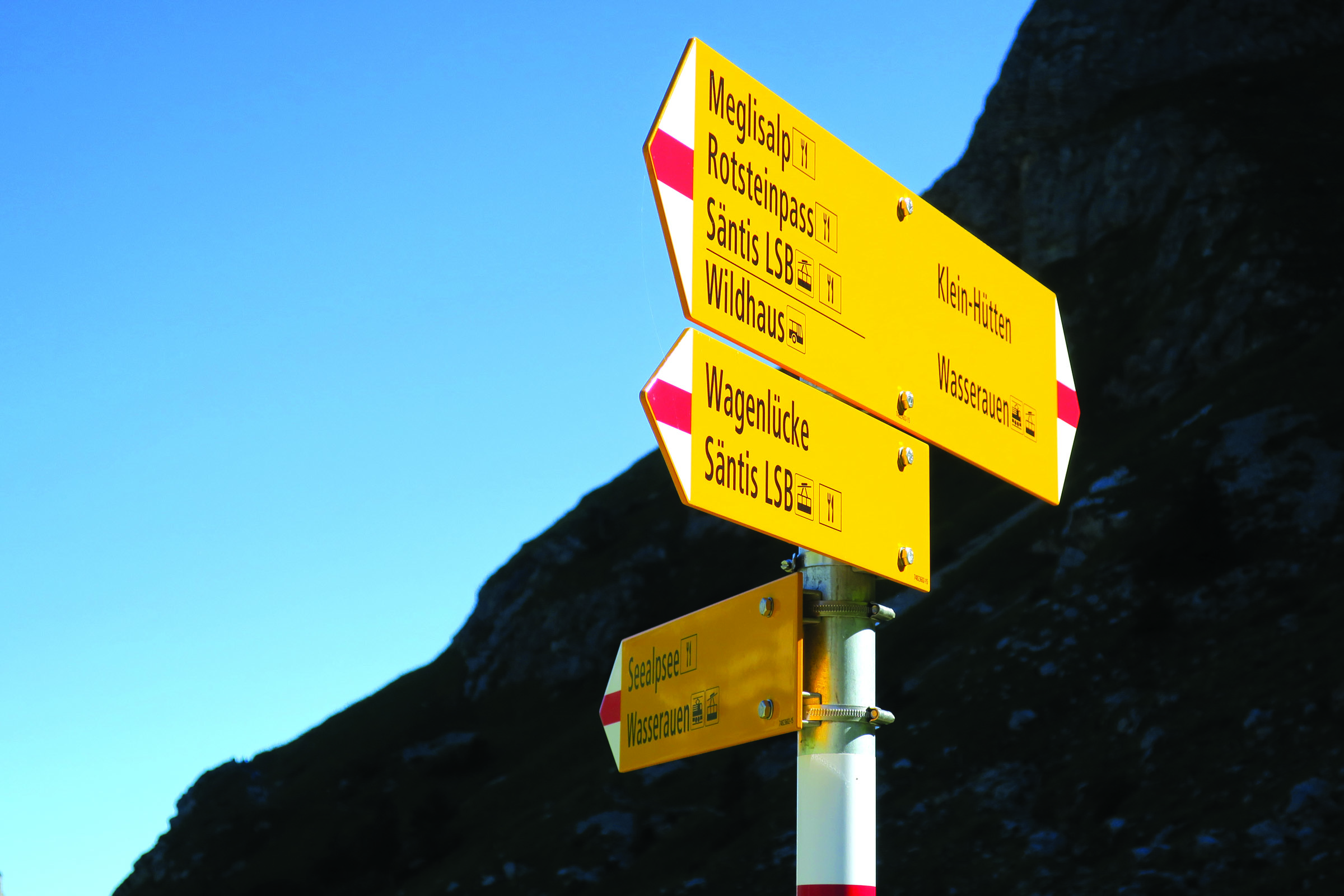
Swiss citizens from all 26 cantons actively exercise their power to preserve what they have; invited to vote on issues several times a year, including environmental, they do so with care. Longstanding legislation ensures 30 per cent of Switzerland’s surface is forested and around half of that is parks of national significance. Recent initiatives, like SwitzerlandMobility, promote networks of hiking, cycling, mountain biking and paddling routes coordinated with public transport.
In the same way every trail in Switzerland seems to lead to comfort food and schnapps, each Swiss trip I take organically leads to the next.
FINDING APPENZELLERLAND
Appenzell Innerrhoden is the country’s second-smallest and least populated canton. It’s over 500 years old with a documented yodelling heritage almost as long. Some farmers still walk their alps barefoot. In 2015 a WhiskyTrek was launched to promote the often overlooked Alpstein massif. Säntis Malt whisky – made with local spring water, peat and barley – was transported in barrels to the Alpstein’s 27 guesthouses to be aged at elevation and then doled out to walkers.
I was drawn to Appenzellerland by all of the above.
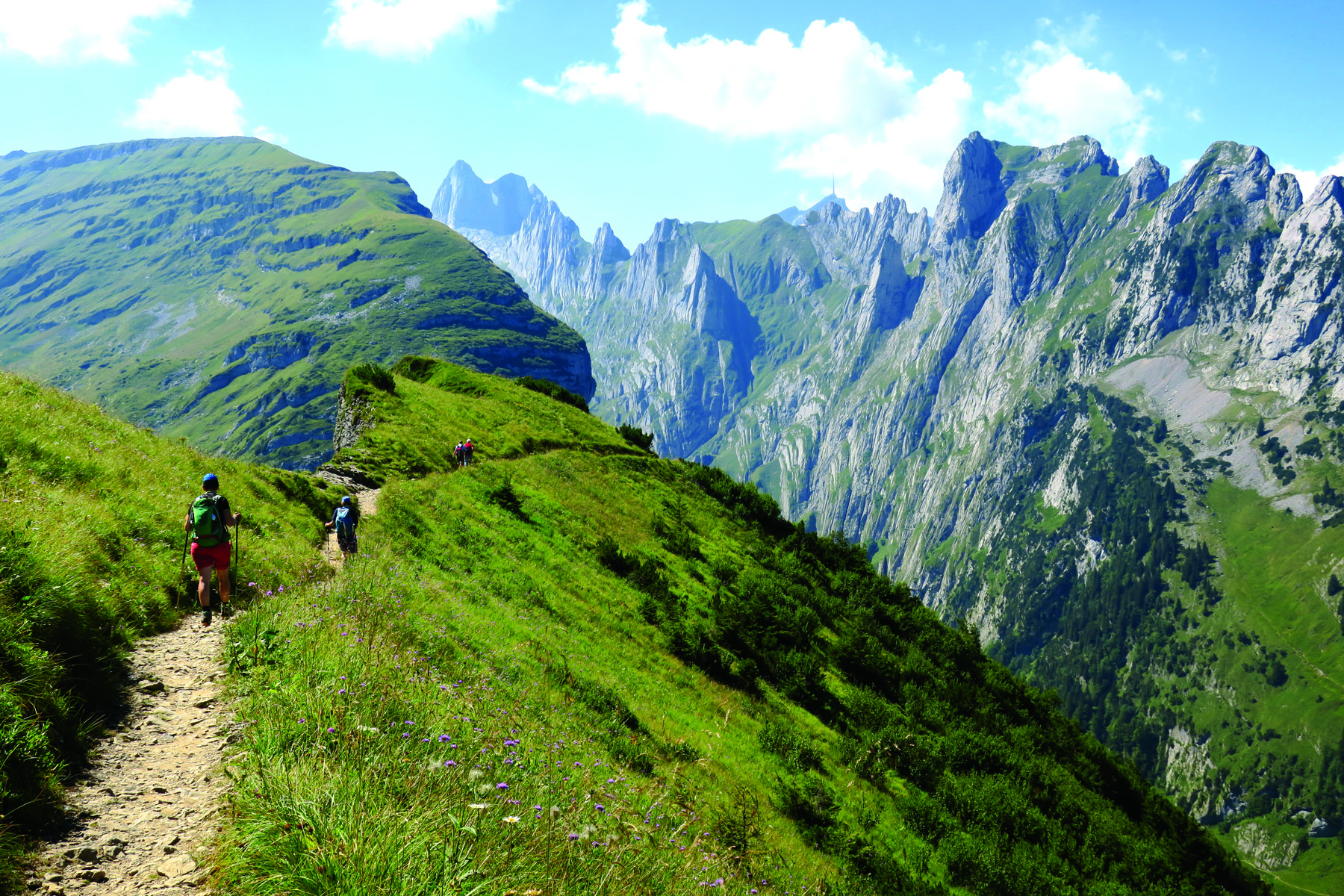
At Hoher Kasten, where I begin my three-day solo WhiskyTrek, there’s an unobstructed view of the Alpstein’s highest mountain: 2,502m Säntis. The massif’s interior scenes are everything from semi-agricultural steep wildflowering meadows of livestock and weathered timber fences, to pine forests, scree slopes, deep gullies and limestone cliffs. Cowbells are often the only sound apart from the occasional helicopter bearing bovine in a sling.
Switzerland’s trails are classified wanderweg (graded footpath), alpiner weg (for mountaineers with ropes) and bergwanderweg (somewhere in between). I mainly tread the latter but, even so, there are still some narrow cliffside tracks and long steep descents. Yet my forgiving route saves me from any truly gruelling climbs: Hoher Kasten to Staubern to Bollenwees (overnight); Meglisalp to Seealpsee (overnight); and Mesmer, Schäfler, Äscher, Ebenalp.
Guesthouses are so well equipped there’s less than 10kg in my pack. And Swiss people are tortoises, not hares: they walk up, down and on the flat at a constant slow-to-medium speed. To which I willingly conform.
Most Alpstein accommodation is multigenerational family-owned-and-operated. My favourite is Meglisalp where I arrive at sunrise to find fresh self-serve chocolate-filled pastries. A mountain man called Urban, who I laugh with for an hour despite sharing no common language, shows me Meglisalp’s barrel of whisky stored in a stone barn.
Everyone’s supplies may have run dry by now but I’d return to the Alpstein in a heartbeat just to check.
ONE GOOD TURN DESERVES ANOTHER
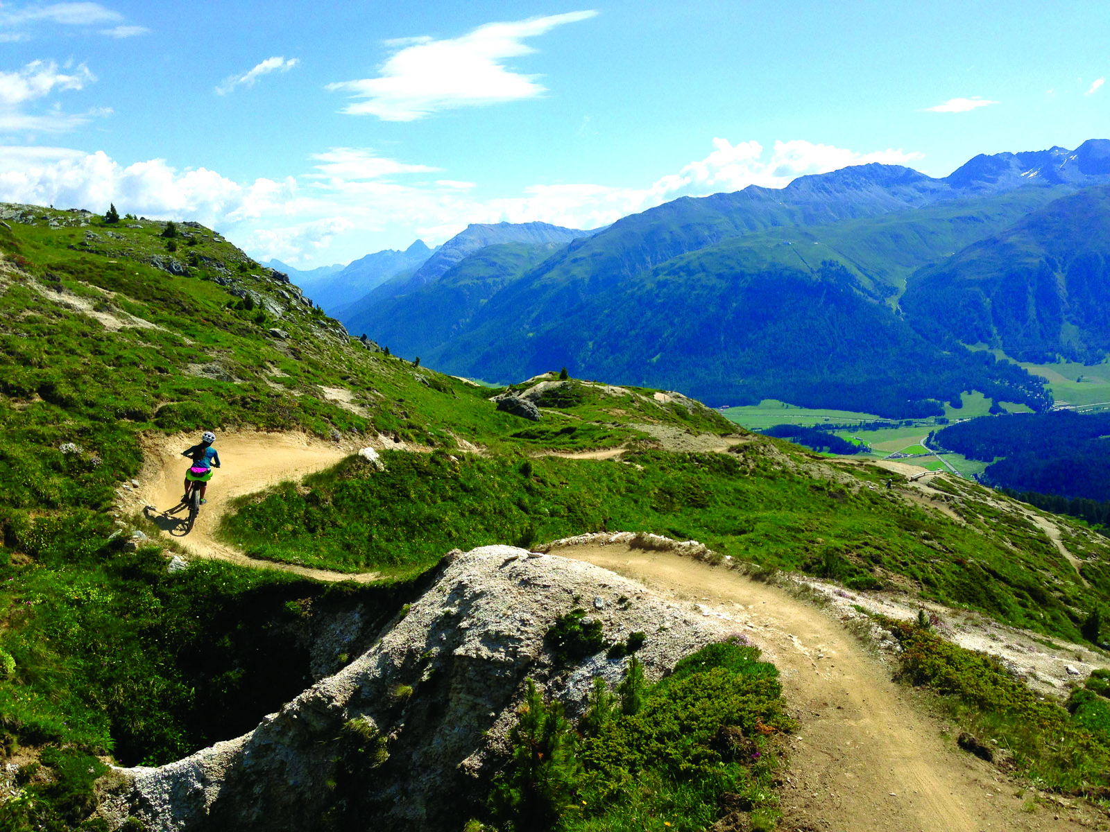
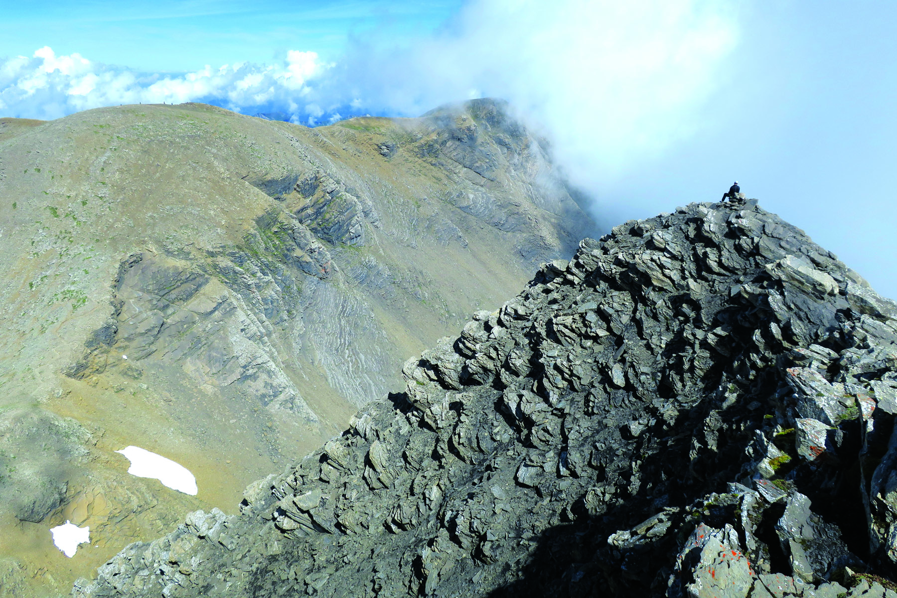
Mountain biking has really gained traction in Switzerland’s largest and most eastern canton, Graubünden, where you’ll hear the country’s oldest language of Romansch spoken. Brand new trails are being carved, with Swiss precision, into a place of 150 valleys, 615 lakes and 937 mountain peaks.
Swiss people have what I’d call a high tolerance for risk. I’m equal parts shit-scared, thrilled and amused on Corviglia flowtrail – above St Moritz at 2,486m – with its cliff-drop edges, ribbon-like track and beginner-intermediate rating. A Swiss travelling companion shows me how it’s done and I’m left eating her dust and nodding in approval. The second time around my berm turns are undeniably smoother.
Graubünden’s mountain resort of Lenzerheide, north-west of St Moritz, is currently considered Switzerland’s number one mountain biking region; the world championships were held there in 2018. In the extreme, its 66.6km Durannapass-Strelapass begins up at 2,600m and is as technical as you can get.
The town of Flims is also on the mountain biking map. Its 7.6km Runca Trail, starting from an elevation of 1,800m, is the longest ‘flow country trail’ in Europe and something I can more realistically work towards. I’m told Flims is also where Switzerland’s first via ferrata can be found but have no idea, at the time, what that term means.
After morning skills training in Flims we cycle around Cauma Lake to Conn Restaurant, which has no road access, to eat handmade ricotta ravioli and Romansch-style chard-wrapped capuns. After lunch I climb the stairs of a nearby lookout over the Upper Rhine Gorge. The Rhine River, I’m told, begins where Graubünden meets the cantons of Ticino and Uri.
IF YOU’RE NOT LIVING ON THE EDGE
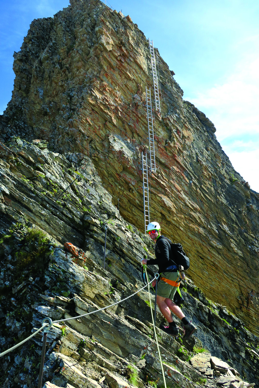
When Italy fought the Austro-Hungarian Empire for their precious Dolomites during World War I, soldiers secured ladders and cables to the treacherous limestone faces of their vertical battlefields. A via ferrata, which loosely translate as iron path or iron way, now has a more recreational role.
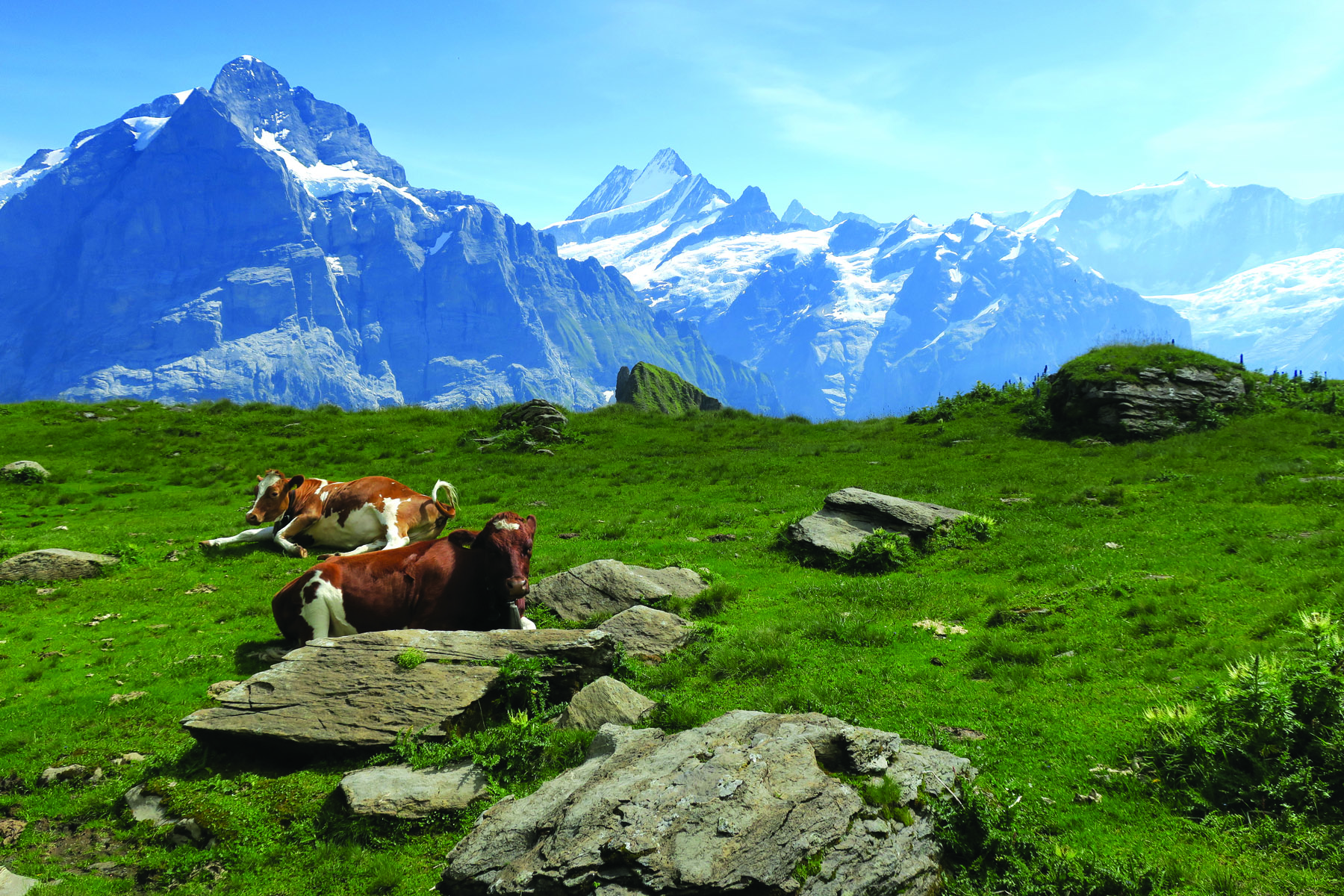
My son-of-a-mountain-guide mountain guide, Beat Hofer, was raised here in the Bernese Oberland where he’s also a forest warden and stone artist. We ride the gondola to Grindelwald-First’s highest stop at 2,166m where I fill my water bottle from one of Beat’s sculpted fountains.
From there we hike up through green meadows of grazing cows, hyperactive marmot and flowering alpine tundra. Above the shrub line it’s a scramble to the western ridge of Schwarzhorn – a shale-surfaced mountain with a glacier on one side – but just as the scramble becomes a climb the via ferrata materialises.
Our route is then dictated by a steel cable secured inches from the ground at attachment points every few metres. Ahead, the cable runs up a sheer cliff-face alongside three consecutive 20-rung steel ladders and disappears over a ledge. From his backpack Beat produced helmets, harnesses and Y-shaped lanyards. Kitted up, I make my way along the line with both carabiners clipped on. Then, at each attachment point, released and re-clip one carabiner at a time.
Schwarzhorn Klettersteig is rated PD – peu difficile or ‘not very hard’ – under the French grading system, so it’s my ideal starter ferrata. On the final ascent, with the iron path behind us, the ridge is no longer steep but there’s an un-survivable drop on either side. My legs should be shaking but the via ferrata experience has built my confidence and, as clouds swirl by, I calmly approach the 2,928m summit.
WATER, WATER EVERYWHERE
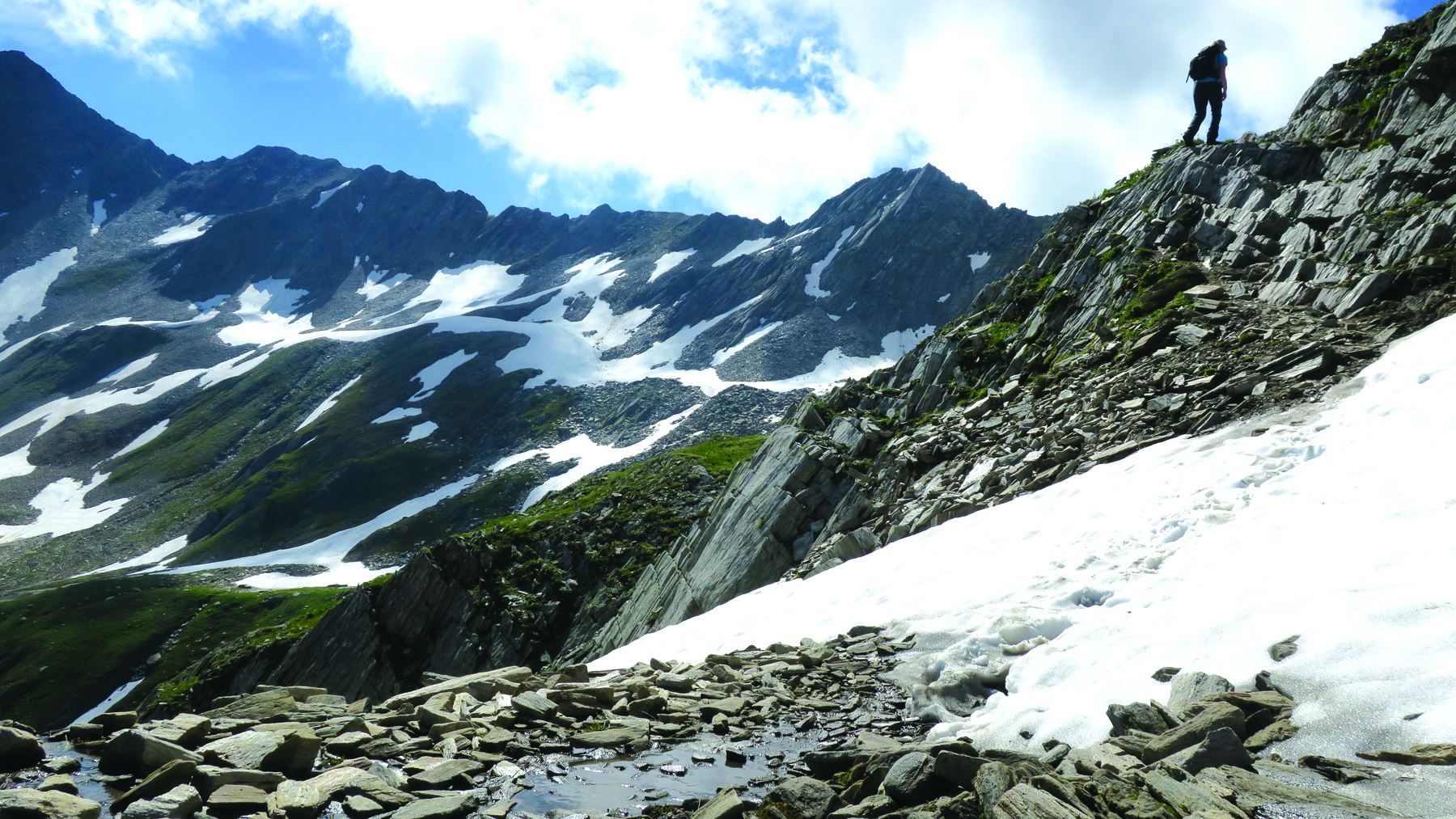
“We never bring water to the mountains, we think it’s silly to carry it,” Miriam Schuler says as we walk to our trailhead from Oberalppass train station. “If you go to a hut you never can avoid the good cake,” is her other key advice for our three days in the mountains of Andermatt Holiday Region. This is where Switzerland’s south-eastern cantons of Uri, Graubünden and Ticino intersect within the Gotthard massif. Miriam is from Uri and, according to other Swiss German speakers, has a funny accent.
There are 16 Swiss Alpine Club huts in this region at elevations between 1,475m and 2,708m and we’re booked into Maighels and Vermigel. Dorm-style rooms are heated and, although huts are unique in architecture and setting, locals distinguish between them according to best food or proximity to a gondola. Pia Schmitt, who’s catered at Maighels Hut for nearly 30 years, is a great conversationalist and demon cook.
Huts here are mainly connected by medium-graded trails that aren’t particularly steep or precipitous by Swiss standards. A German friend living in Switzerland later scoffed and called the region “quite plain” compared to other parts of Switzerland and I scoffed and called him “quite spoilt”.
Andermatt Holiday Region has vast green glacially-carved valleys, rocky peaks with goats trotting around on them, gorges, rushing rivers, scree slopes, snow fields. We have a cloud-level picnic lunch on the last day on the top of 2,776m Giübin with views into Italian-speaking Ticino.
“We say this region is a water castle,” Miriam explains, because it’s home to the sources of four major rivers. One of my favourite Swiss idiosyncrasies is that this pristine waterlogged country of recycling warriors – 94 per cent of old glass and 81 per cent of PET containers make their way to special collection points instead of household bins – provides only bottled water in most of its restaurants.
Miriam and I vow to swim daily. Only a few hours after getting off the train we’re having homemade cake with fresh cream and coffee with schnapps in the sun at Badus Hut, then find a secluded spot off the track and jump naked into the freezing Lake Toma – the source of the Rhine.
So now I have my heart set on hiking this region’s five-day Vier-Quellen-Weg to the sources of the Reuss, Rhine, Rhône and Ticino. And already have plans in place to walk the first 45km of the Via Alpina Bear Trek in the Bernese Oberland under the gaze of Eiger, Mönch and Jungfrau. And I’d really like to do the Lakes Route cycle tour through Gstaad and Gruyéres.
You see? Switzerland is a dangerous recreational substance. You have no idea you’re hooked until it’s too late.
THREE EPIC, DISTINCTIVELY SWISS, LONG DISTANCE SUMMER TREKS
Via Alpina
The Via Alpina is a classic Swiss long-distance hike. Crossing 14 of the country's most beautiful alpine passes, it leads through the northern Alps of Switzerland (Vaduz – Montreux, via six cantons). Its best attribute is the variety it offers. Trekkers can expect to be delighted by the culture, geology, topography and panorama readily on offer durung the route. As well the Via Alpina skirts through and around many famed mountains, villages and lakes. There's a range of services on offer for every style, from 4-star hotel to mountain hut, tranquil sanctuaries of relaxation to sophisticated tourist destinations. It's a perfect way to discover the real Switzerland. On the Via Alpina, long-distance hikers will experience the picture-postcard mountain world of Switzerland first-hand.
Alpine Passes Trail
This is a challenging and wild experience, certain to deliver a memorable life highlight in the heart of stunningly unique Swiss Alpine wilderness. The Alpine Passes Trail connects Chur with Lake Geneva, via some of the most beautiful passes in the Graubünden and Valais Alps. Ideal for experienced long-distance hikers, the Trail passes through immaculate Swiss locations and incorporates many scenic peaks and overnight stays in classic mountain huts. It's an experience certain to linger in memory.
Jura Crest Trail
A gentle and relatively unknown proposition for non-Swiss hikers, this is the oldest long-distance trail in Switzerland. Connecting Zurich and Geneva over the Jura mountains, the Jura landscape, tranquil appeal of the remoteness, alpine cuisine and glorious views make this easy graded hike a local favourite.
TRAVEL TIPS
Getting there
Swiss International Air Lines, along with airline partners, offers daily connections from Sydney and Melbourne via Hong Kong, Bangkok and Singapore.
Getting around
Swiss Travel Pass gives unlimited access to all public transport in Switzerland including buses, trains and boats, plus 50 per cent off mountain rail and cable car tickets.
When to go
Summer season generally runs May to September but varies between regions. Less lines and crowds on weekdays.
Maps
Comprehensive hardcopy maps can be found at local tourist information centres, with increasingly more online maps and region-specific apps available.
Guides and gear
The Swiss don’t compromise on quality so expect top-of-the-range rental equipment and highly capable guides.
Where to stay
There are mountain huts and guesthouses throughout Switzerland’s alpine regions. Book ahead, arrive in time for dinner and expect a rowdy sociable crowd on Friday and Saturday evenings.
Head to myswitzerland.com for more information.